Diagram and Data of the Hartford-Brainard Airport
Visit our page on AirNav.com.
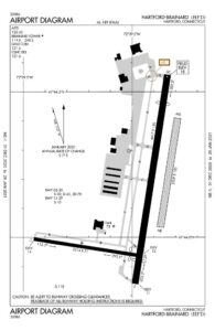
Airport Data
LOCATION: 3 SE of Hartford
LAT: 41°44.18
LONG: 72°39.01
ELEVATION: 19’ ASL
Runways
02-20-4418’x150’ (grooved asphalt)
11-29-2315’x70’(asphalt
NE-SW 2350’x150’(turf)
Traffic Aids
Tower
Segmented Circle
Wind Socks (lighted)
Lighting
Rotating Beacon C & G Obstruction
02/20,HIRL,REIL & VASI;11/29 MIRL
Traffic Pattern
Standard 1000’ AGL
Fuel Available: 100LL, JET-A
Parking: Hangars and Tie-Downs
Airframe Service: MAJOR
Powerplant Service: Major
Bottled Oxygen: None
Bulk Oxygen: None
Instrument Approach Procedures
GPS RWY 02
LDA RWY 02
VOR OR GPS-A
RIVER VISUAL RWY 02
Weather: ASOS
Noise Abatement Procedures
- Runway 2 is the designated Calm Wind Runway.
- When the wind is less than 5 knots, and traffic and other conditions permit, Runway 2 will be utilized for departures and Runway 20 used for arrivals.
- Touch-and-go operations and practice instrument approaches should be conducted Monday through Saturday between 7:00 am and 10:00 pm, and between 9:00 am and 10:00 pm on Sunday.
- Turf runway closed during winter months from November 2 to April 30, except ski-equipped aircraft & helicopter training.
- Maintenance run-ups should be conducted between 7:00 am and 10:00 pm.