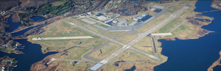
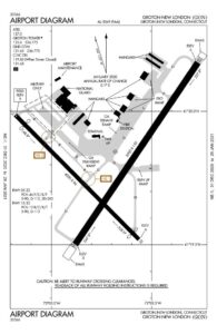
Diagram and Data of Groton-New London Airport
Visit our page on AirNav.com.
Airport Data
LOCATION: 3 MI SE of Groton
LAT: 41°19.80
LONG: 72°02.71
ELEVATION: 10’ ASL
Runways
05-23-5000’x150’ (grooved asphalt)
15-33-4000’x96’ (grooved asphalt)
Traffic Aids
Tower
Wind Sock (lighted)
Lighting
Rotating Beacon C&G
05-23 & 15-33 = high intensity
Approach Lighting Navaids
Runway 05 – MALSR, PAPI (P4L),
Runway 05 – RVR
Runway 23 – REIL, VASI (V4L)
Runway 33 – REIL, PAPI
WAAS
Traffic Pattern
Standard 1000’ AGL
Fuel available: 100LL JET-A
Parking: Tiedowns, Hangars
Airframe service: MAJOR
Powerplant service: MAJOR
Bottled oxygen: HIGH/LOW
Bulk oxygen: HIGH/LOW
Instrument Approach Procedures
ILS OR LOC RWY 05
RNAV (GPS) RWY 05
RNAV (GPS) RWY 23
RNAV (GPS) RWY 33
VOR RWY 05
VOR RWY 23
Weather: ASOS, SAWS
Noise Abatement Procedures
- Departing Runway 5: Turn left heading 020 degrees until reaching 1,000 feet, then on course.
- Departing Runway 23: Turn left heading 210 degrees until reaching 1,000 feet, then on course.
- Departing Runway 33: Fly runway heading until reaching 1,000 feet then on course.
- Runway 23 is the designated Calm Wind Runway.
- Aircraft operators are encouraged to refrain from touch-and-go operations between the hours of sunset and 8:00 am. No touch-and-go operations are permitted between 10:00 pm and 6:00 am.
- No maintenance run-ups permitted between 10:00 pm and 7:00 am, except when required to meet an early morning published flight schedule.